Info Seite, AFNORTH - ACE-High-Journal
Hauptmenü:
ACE-High System > Bereich, AFNORTH > Norwegen
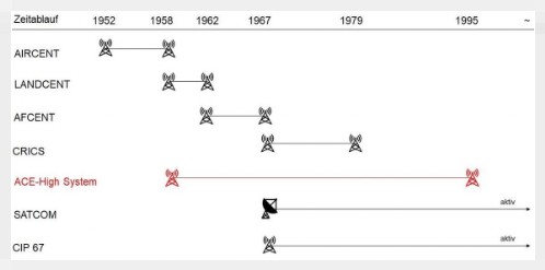
ACE-High System von 1958 bis 1995 (1) (2)
ACE-High System (Allied Command Europe Tropospheric Forward Scatter Communications Systems)
______________________________________________________________________________________________________________________________________________________________________________________________________________
Info Seite
_____________________________________________________________________________________________________________________________________________________________________________________________________________________________________________

(5) aktive NATO-Liegenschaft, ACE-High Station Kristiansand, 1981, by Jørn Christiansen
_____________________________________________________________________________________________________________________________________________________________________________________________________________________________________________
| Norwegen | ||
| Bodø (Brevik) 67°10'21.76"N/15°01'29.94"O - 802 m.üNN Antennen ü. GDN : Scatter, Höhe 20 m. Antennen ü. GDN : L.o.S. Tower, Höhe unbekannt Site Code : (ND) NKLZ Status : Aufgegebene Nutzung Status heute : Renaturierte Liegenschaft | Kletkov Antennen ü. GDN : L.o.S. Tower, Höhe unbekannt Position : unbekannt Site Code : (nda) NVAZ Status : Aufgegebene Nutzung Status heute : unbekannt | Høggumpen 69°03'32.85"N/18°00'05.13"O - 1011 m.üNN Antennen ü. GDN : L.o.S. Tower, Höhe unbekannt Site Code : (nca) NHGZ Status : Aufgegebene Nutzung Status heute : unbekannt |
| Kolsås 59°55'07.80"N/10°30.58'10"O - 330 m.üNN Antennen ü. GDN : L.o.S. Tower, Höhe unbekannt Site Code : (nga) NKOZ Status : Aufgegebene Nutzung Status heute : unbekannt | Birkedal 58°27'13.58"N/8°27'41.86"O - 324 m.üNN Antennen ü. GDN : Scatter, Höhe 20 m. Antennen ü. GDN : L.o.S. Tower, Höhe unbekannt Site Code : (NH) NSMZ Status : Aufgegebene Nutzung Status heute : Renaturierte Liegenschaft | Vikedal 59°31'40.46"N/5°54'12.25"O- 792 m.üNN Antennen ü. GDN : Scatter, Höhe 20 m. Antennen ü. GDN : L.o.S. Tower, Höhe unbekannt Site Code : (NJ) NLYZ Status : Aufgegebene Nutzung Status heute : rekultiviertes Gelände |
| Mågerø 59°09'22.44"N/10°26'19.01"O - 14 m.üNN Antennen ü. GDN : L.o.S. Tower, Höhe unbekannt Site Code : (ngb) NVEZ Status : Aufgegebene Nutzung Status heute : Militär Terrain | Mosjøen 65°52'41.91"N/13°18'13.62"O - 626 m.üNN Antennen ü. GDN : Krupp Scatter 1, Höhe 20 m. Antennen ü. GDN : Scatter 2, Höhe unbekannt Antennen ü. GDN : L.o.S. Tower, Höhe unbekannt Site Code : (NE) NMOZ Status : Aufgegebene Nutzung Status heute : Renaturierte Liegenschaft | Loerenfallet 60°03'34.12"N/11°16'09.20"O - 237 m.üNN Antennen ü. GDN : Scatter, Höhe 20 m. Antennen ü. GDN : L.o.S. Tower, Höhe unbekannt Site Code : (NG) NSOZ Status : Aufgegebene Nutzung Status heute : Renaturierte Liegenschaft |
| Senja 69°03'32.85"N/18°00'05.13"O - 1011 m.üNN Antennen ü. GDN : Scatter, Höhe unbekannt Antennen ü. GDN : L.o.S. Tower, Höhe unbekannt Site Code : (NC) NSEZ Status : Aufgegebene Nutzung Status heute : unbekannt | Enebakk 59°46.48'36"N/11°00'13.59"O - 475 m.üNN Antennen ü. GDN : L.o.S. Tower, Höhe unbekannt Site Code : (ngx) NSVZ Status : Aufgegebene Nutzung Status heute : Unbekannte Nutzung | Selbu 63°18'39.92"N/10°56'15.71"O - 695 m.üNN Antennen ü. GDN : Scatter, Höhe 20 m. (Kennedy OH Antennen ?) Antennen ü. GDN : L.o.S. Tower, Höhe unbekannt Site Code : (NF) NSBZ Status : Aufgegebene Nutzung Status heute : Renaturierte Liegenschaft |
Ugla 63°25'15.27"N/10°15'06.65"O - 552 m.üNN Antennen ü. GDN : L.o.S. Tower, Höhe unbekannt Site Code : (nfa) NGRZ Status : Aufgegebene Nutzung Status heute : unbekannt | ||
| Codierung [Z] für das ACE-High System | Allied Command Europe Tropospheric Forward Scatter Communication System Troposphären- und Richtfunk gestütztes System. |
Beispiel: NMOZ - Station Mosjöen - Norway N - N (Norway) MO - Station Mosjöen Z - ACE-High System | |
______________________________________________________________________________________________________________________________________________________
______________________________________________________________________________________________________________________________________________________
Die Entstehung von "AFNORTH"
Alliierte Streitkräfte Nordeuropa (engl. Allied Forces Northern Europe; AFNORTH)
"Die Allied Forces Northern Europe (AFNORTH; deutsch Alliierte Streitkräfte Nordeuropa) war ein Kommandobereich der NATO für Nordeuropa mit dem Hauptquartier in Oslo und von 1954 bis 1994 in Kolsås bei Bærum, Norwegen. AFNORTH wurde 1952 aufgestellt. Nach dem Ende des Kalten Kriegs wurde AFNORTH 1994 in den neuen Kommandobereich Allied Forces Northwestern Europe (Alliierte Streitkräfte Europa Nordwest; AFNORTHWEST) integriert. Zum Verantwortungsbereich (area of responsibility) von Allied Forces Northern Europe gehörten die Staaten Dänemark und Norwegen, sowie die Länder Hamburg und Schleswig-Holstein. Außerdem gehörten hierzu die Bereiche Nordsee, Skagerrak, Kattegat und die Ostsee mit Belten und Sund. Die Befehlshaber waren zuletzt Offiziere im Rang eines Generals oder Admirals aus dem Vereinigten Königreich. Mit dem Akronym AFNORTH wurde von 2000 bis 2004 eine Kommandobehörde der NATO bezeichnet, das Regional Command Allied Forces North Europe, dem späteren Allied Joint Force Command Brunssum." [4]
______________________________________________________________________________________________________________________________________________________
Beschreibungen
Link Seiten, Wikipedia
"Gegen Ende des Kalten Krieges bestand folgende Kommandostruktur:
Alliierter Kommandobereich Europa (engl. Allied Command Europe; ACE)
Allied Command Europe Mobile Forces (AMF)
RAF Strike Command
Alliierte Streitkräfte Nordeuropa (engl. Allied Forces Northern Europe; AFNORTH)
Alliierte Streitkräfte Mitteleuropa (engl. Allied Forces Central Europe; AFCENT)
Alliierte Streitkräfte Südeuropa (engl. Allied Forces South Europe; AFSOUTH)
Alliierter Kommandobereich Atlantik (engl. Allied Command Atlantic; ACLANT) und
Alliierter Kommandobereich Ärmelkanal (engl. Allied Command Channel; ACCHAN)" [3]
______________________________________________________________________________________________________________________________________________________
Link Seiten, sonstige Publikationen
Thema, Schließung des "ACE-HIGH" System in der AFNORTH Region.
Autor - Kaere N.Hansen
Quelle - AFNORTH Magazin 02/1992 [5]
Hinweis - Der Bericht ist noch nicht von dem Autor zur Veröffentlichung freigegeben.
Quelle - AFNORTH Magazin 02/1992 [5]
Hinweis - Der Bericht ist noch nicht von dem Autor zur Veröffentlichung freigegeben.
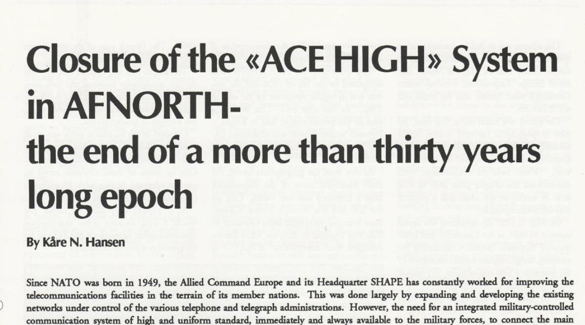
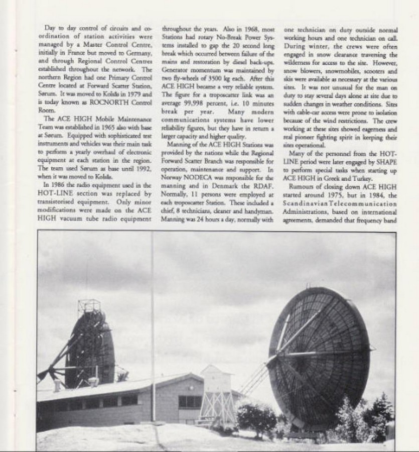
"Closure of the „ACE-HIGH“ System in AFNORTH- the end of a more than thirty years long epoch.
Since NATO was born in 1949, the Allied Command Europe and its Headquarter SHAPE has constantly worked for improving the telecommunications facilities in the terrain of its member nations.This was done largely by expanding and developing the existing networks under control of the various telephone and telegraph administrations.However, the need for an integrated military-controlled communication system of high and uniform standard, immediately and always available to the military forces, to connect the main operational centres and to serve the radar outposts dispersed throughout the European NATO countries, commenced with a scheme approved in august 1956".[5]
"Schließung des "ACE-HIGH" System in der AFNORTH Region. Das Ende einer mehr als 30 Jahre langen Epoche.
Die NATO wurde im Jahr 1949 gegründet; das Allied Command Europe (ACE) mit seinen Hauptquartier, dem Supreme Headquarters Allied Powers Europe „SHAPE“, war u.a. für die Verbesserung der Telekommunikation - Einrichtungen in den Ländern der NATO - Mitgliedsstaaten zuständig.Dies wurde vor allem durch den Ausbau und die Entwicklung der bereits bestehenden Netzwerke unter der Kontrolle der verschiedenen nationalen Telefon und Telegraf Verwaltungen realisiert.
Allerdings erforderte dieses die Notwendigkeit eines integrierten von dem Militär kontrollierten Kommunikationssystem, mit einem hohen technischen und einheitlichen Standard (Abhörsicherheit und Verschlüsselung der Informationen), der sofort und immer für die Streitkräfte zur Verfügung steht, um die wichtigsten operativen Zentren (regionale Hauptquartiere), die Radar - Außenposten zu verbinden, welche verstreut in den verschiedenen europäischen NATO-Ländern installiert waren. Im August 1956 wurden hierzu die geprüften Standard Richtlinien und somit ein einheitlicher Standard erstellt." [5]
______________________________________________________________________________________________________________________________________________________
eine schöne Erinnerung ...

_____________________________________________________________________________________________________________________________________________________________________________
Bild - Quellenangaben
(PA) Privates Archiv
(1) Geographische Ansicht
(1) Google Earth, Google Street
(2) Wikipedia, Coat of arms of Allied Forces Northern Europe
(3) Station Codes and Network Routes
(3) NATO Linienplan, 1959
(4) Geographic Locations of the NICS
(4) NATO Linienplan, 1976
(5) aktive NATO-Liegenschaft, 1981
(5) by Jørn Christiansen
(6) Quellenschutz, ID 201_03