Piacenza - Air Base - ACE-High-Journal
Hauptmenü:
- Homepage
-
AIRCENT 1952 > 1958
- Info Seite
- AIRCENT Linienplan
- AIRCENT HQ Camp Guynemer
- A-1. Camp Guynemer
- A-2. Hauteurs de la Solle
- A-3. Melun
- A-4. Marly-le-Roi
- 4. Jossigny
- 5. Éméville
- 6. Margival-Laffaux(1)
- LANDCENT 1952 >1962
-
AFCENT/JCA 1962 >1967
- Info Seite
- AFCENT Linienplan
- AFCENT HQ - Fontainebleau
- 1. Camp Guynemer
- 2. Fontainebleau - Maintenance
- 3. St. Méry-Bombon
- 4. Bussières (La Haute-Maison)
- 5. Dampleux
- 6. Lagery
- 7. St. Erme
- AFCENT CRICS 1967 >1979
-
AFCENT CIP 67, ab 1967
- Info Seite
- AFCENT Linienplan
- Arnheim
- Aurich
- Bad Bergzabern
- Baden-Söllingen
- Bann (Kindsbach)
- Baraque-de-Fraiture
- Barnsdorf
- Battice (Fort)
- Beckum
- Bielefeld
- Böblingen
- Bonn (Hardthöhe)
- Brockzetel
- Brunssum
- Cannerberg (Bunker)
- Damme
- Dietenwengen
- Dötlingen
- Drabenderhöhe
- Ellerspring
- Erbeskopf
- Euskirchen
- Feldberg
- Gross Reken
- Hehn
- Herkenbosch
- Himmelsberg
- Hochkelberg
- Hornisgrinde
- Ibbenbüren
- Irndorf
- Kesternich
- Kindsbach (Cave)
- Kolbenberg
- Lammersdorf
- Langerkopf
- Lantin
- Leistadt
- Leopoldsburg
- Lübbecke
- Maastricht
- Markelo
- Messstetten
- Mönchberg
- Nordhelle
- Nottuln
- Oberabtsteinach
- Obertshausen
-
AFCENT Sonstige Stationen
- Info Seite
- AFCENT Übersichtsplan
- Adinkerke-Site 030
- Altenwalde
- Bad Münstereifel
- Bassenge-Glons
- Battice-Site 024
- Baumholder
- Ben-Ahin-Site Mx
- Brüssel-Evere NATO HQ
- Camp Elsenborn
- Court-Saint-Etienne
- Court-Saint-Etienne-Site Mx
- Elmpt (Brüggen)
- Everberg-Site 115
- Genk
- Hannut-Site 055
- Hannut-Site RTB
- Hottorf
- Kester-Heide-Site Mx
- ACE-High-System Europa, Info Seite
-
ACE-High-System, ACCHAN,ab 1958
- Info Seite
- England
-
ACE-High-System, AFNORTH,ab 1958
- Info Seite
-
Dänemark
- ACE-High System
- Umgebung - Sonstige Objekte
- Norwegen
-
ACE-High-System, AFCENT,ab 1958
- Info Seite
- Link Seiten-Übersicht
-
Deutschland
- ACE-High System
-
Umgebung - Exkursionen
- Info Seite
- Bonndorf - Wutachschlucht
- Freudenstadt - Holzmichelweg
- Freudenstadt - Rothirschweg
- Hinterzarten - Ravennaschlucht
- Hinterzarten - um den Feldberg
- Kniebis - Lotharpfad
- Lübeck - Ostseeradweg
- Pforzheim - Ostweg
- Pforzheim - Mittelweg
- Pforzheim - Westweg
- St Georgen - Wanderweg E8
- Stühlingen - Schluchtensteig I
- Stühlingen - Schluchtensteig II
- Triberg - Uhrenträgerweg
- Vossenack - Hürtgenwaldmarsch
- Freiburg - Konstanz - Querweg
- Astorga - Camino de Santiago II
- Logrono - Camino de Santiago I
-
Umgebung - Militärische Objekte
- Info Seite
- Air Base
- Munitionslager
- Nike FlaRak Stellungen
- Pershing FlaRak Stellungen
- Polygone Stellungen
- Transmitter
- Truppenübungsplatz-Kasernen
- US Stellungen
-
WKII Objekte
- Info Seite
- Aurich - Flakstellung
- Bad Bergzabern - Museum
- Bad Münstereifel - FHQ "Felsennest"
- Gemünd - NS-Ordensburg Vogelsang
- Gemünd - Igel Stellung Vogelsang
- Kniebis - FHQ "Tannenberg"
- Lammersdorf - Höckerlinie
- Langschoß - Wasserbunker
- Niedersimten - Museum Gerstfeldhöhe
- Paustenbach - Eifelkreuz
- Schmithof - Höckerlinie
- Seebach (Hornisgrinde) - LVZ
- Simonskall - Museum Sanitätsbunker
- Umgebung - Städte/Ortschaften
-
Umgebung - Transmitter
- Info Seite
- Alexanderschanze - Transmitter (Mobil)
- Bremen Woltmershausen - Transmitter
- Bremen - Fernmeldeturm
- Dannenfels - Sender Donnersberg
- Düsseldorf - Rheinturm
- Gernsbach - Hohloh Transmitter
- Gollenberg - Transmitter
- Großhau - Fernmeldeturm
- Lauschied - Transmitter
- Mönchengladbach - FMT Transmitter
- Nottuln - WDR Sender
- Ober-Abtsteinach - HR Transmitter
- Reichweiler - Transmitter
- Schiefbahn - Fernmeldeturm
- Schömberg - Sender Langenbrand
- Seebach (Hornisgrinde) - Mobilfunk
- Seebach (Hornisgrinde) - SWR
- Seebach (Hornisgrinde) - Telekom
- Staffel - FMT Transmitter
- Sulzbach-Rosenberg - Mobilfunk
- Sulzbach- Rosenberg - Transmitter
- Waldböckelheim - Transmitter
- Wildeshausen - Transmitter
- Würselen- Mobilfunk Transmitter
-
Umgebung - Sonstige Objekte
- Info Seite
- Bambergerhof - BNetzA Peiler
- Bann - Site C
- Calmbach - Klinik Charlottenhöhe
- Darßer Ort-NVA Stellung
- Feldberg - Horst Garbe
- Karlsruhe - 2tes Meeting
- Kniebis - Hotel Alexanderschanze
- Langschoß - Feuerwachtturm
- Wollseifen - das Dorf
- Mönchengladbach - Flughafen
- Feldberg - Taunus
- Mülheim - Flughafen
- Sinsheim - Technikmuseum
- Weeze - Schloss Wissen
- Feldberg - Schwarzwald
- Dannenfels - Ludwigsturm
- Kühlungsborn - DDR Grenzturm
- Börgerende - DDR Grenzturm
- Schwalmtal - Fabrikanlage
- Eckersweiler - Aussenfeuerstellung
- Umgebung - Gedenkstätten
-
Belgien
- ACE-High System
-
Umgebung - Militärische Objekte
- Info Seite
- Truppenübungsplatz-Kasernen
- WKI Festungen
- WKII Bunker
- WKII Festungen
- Umgebung - Städte/Ortschaften
- Umgebung - Transmitter
- Umgebung - Sonstige Objekte
- Umgebung - Gedenkstätten
-
Niederlande
- ACE-High System
- Umgebung - Militärische Objekte
- Umgebung - Städte/Ortschaften
- Umgebung - Sonstige Objekte
- Umgebung - Gedenkstätten
-
Frankreich
- ACE-High System
-
Umgebung - Militärische Objekte
- Info Seite
- Objekte-WKI
- Objekte-WKII
-
Objekte-Maginot-WKII
- Ligne Maginot Übersicht
- 8 S.F. de la Crusnes
-
9 S.F. de Thionville
- Ligne Maginot Übersicht
- 9 S.F. Thionville Übersicht
- Rochonvillers - Abri du Grand Lot
- Angevillers - Camp d`Angevillers
- Rochonvillers - Casemate d`Escherange Ouest
- Rochonvillers - Casemate du Grand Lot
- Rochonvillers - Blockhaus 1 - du Petit Lot
- Rochonvillers - Blockhaus 2 - du Petit Lot
- Rochonvillers - G.O. Rochonvillers Bloc 9
- Rochonvillers - G.O. Rochonvillers
- 10 S.F. de Boulay
- 12 S.F. de la Sarre
- 13 S.F. de Rohrbach
- 14 S.F. des Vosges
-
15 S.F. de Haguenau
- Ligne Maginot Übersicht
- 15 S.F. de Haguenau Übersicht
- Birlenbach - Abri de tir de Birlenbach
- Bremmelbach - Casemate Nord
- Drachenbronn - Casernement de Drachenbronn
- Drachenbronn - G.O. Hochwald Est
- Drachenbronn - G.O. Hochwald Ouest
- Hatten - Abri de Hatten
- Hatten - Abri de tir
- Hatten - Casemate Esch
- Hatten - Casemate la Selz
- Hatten - Observatoire
- Oberhof - G.O. Schoenenbourg
- Pfaffenschlick - Abri de tir Pfaffenschlick Sud
- Rittershoffen - Casemate du Bois 1
- Rittershoffen - Casemate du Bois 2
- Rittershoffen - Casemate du Bois 3
- Polygone Stellungen
- Umgebung - Städte/Ortschaften
- Umgebung - Sonstige Objekte
- Umgebung - Gedenkstätten
-
ACE-High-System, AFSOUTH,ab 1958
- Info Seite
- Link Seite
-
Italien
-
ACE-High System
- Aviano Lame Tail
- Catanzaro
- Cavriana
- Dosso dei Galli
- Dosso dei Galli Bilddokumentationen
- Dosso dei Galli 2009 "Jubiläum - 40 Jahre"
- Dosso dei Galli 2019 "Jubiläum - 50 Jahre"
- Lame Concordia
- Latina School
- Livorno
- Livorno Bilddokumentationen
- Malta
- Martina Franca
- Monte Iacotenente
- Monte Lauro
- Monte Vergine
- Monte Vulture
- Naples
- Naples Tail
- Pietra Ficcata
- Rome
- Rome Tail
- Verona Tail
- Verona Torre 4
- Umgebung - Exkursionen
- Umgebung - Militärische Objekte
-
Umgebung - Städte/Ortschaften
- Info Seite
- Affi - Bastia San Michele
- Allumiere
- Agrigento
- Bagolino
- Brescia
- Breno
- Carrara
- Catania
- Civitavècchia
- Collio
- Firenze
- Genova
- Isola di Capri
- Isola di Ischia
- Isola di Procida
- Lago di Garda
- Lago di Idro
- Lago di Iseo
- Lago di Ledro
- Lerici
- Milano
- Monte Etna
- Monte Vesuvio
- Napoli
- Paestum
- Pompeji
- Pozzuoli
- Pisa
- Roma
- Savona
- Sicilia
- Siracusa
- Tuscania
- Tolfa
- Viareggio
- Venezia
- Viterbo
-
ACE-High System
-
Locales NATO / NTTS System
- Info Seite
- Nationaler Linienplan
- SatCom F14
- Aviano - Air Base
- Bunker West Star
- Heliport West Star
- Bunker San Michele
- Bunker Monte Moscal
- Monte Tondo
- "Backyard" Grezzana
- Volta Mantova - Air Force
- Ghedi - Air Base
- Monte Maddalena
- Monte Venda - Padua
- Bunker Monte Venda
- Palazzo Carli
- Piacenza - Air Base
- Cavriana
- Dosso dei Galli
- Livorno
- Lame Concordia
- Vicenza - Air Base
- Monte Alto (VI)
- Romano d`Ezzelino (VI)
- Monte Comerlati (VV) Site W
- Caneva (PN)
- Milano
- Solbiate Olona
- Sacile-Site H
- Site J
- Motta di Livenza
- Vittorio Veneto
- Istrana
- Poggio Renatico
-
Griechenland
- ACE-High System
- Umgebung - Städte/Ortschaften
- Türkei
-
NATO Bunker, Kommandostäbe, Luftraum
- Info Seite
- England
- Norwegen
- Dänemark
-
Deutschland
- Bad Neuenahr, "Marienthal THW2"
- Bodenmais, Radar Luftraumverteidigung
- "Balduin" Brockzetel
- Brockzetel - Radar Luftraumüberwachung
- "Balduin" Rx Site
- "Balduin" Tx Site
- "Castlegate" Linnich
- "Castlegate" Tx Site
- "Cave" Kindsbach
- "Erwin" Börfink
- Erbeskopf - Radar Luftraumüberwachung
- "Erwin" Rx Site
- "Erwin" Tx Site
- "Erich" Erndtebrück
- Erndtebrück - Radar Luftraumüberwachung
- "Erich" Rx Site
- "Erich" Tx Site
- "Kirspenich THW3"
- "Martin" Messstetten
- Messstetten - Radar Luftraumüberwachung
- "Martin" Rx Site
- "Martin" Tx Site
- "GSVBw 44" St. Martin
- "Arius-RUF I" Ruppertsweiler
- "Arius-RUF I" Rx Site Breitenbach
- "Arius-RUF I" Tx Site Hundsbach
- "Arius-RUF II" Ruppertsweiler
- Staffel - Postbunker
- Nörvenich - Air Base
- "Udo" Uedem
- Marienbaum - Radar Luftraumübewachung
- "Udo" Tx Site (1)
- "Udo" Tx Site (2)
- "Udo" Rx Site
- "RIC" Laarbruch
- "Steinfurt" Satzvey
- "Gustav" Königshofen
- Lauda - Radar Luftraumüberwachung
- "Gustav" Rx Site
- "Gustav" Tx Site
- Elmenhorst - Radar Luftraumverteidigung
- Belgien
- Niederlande
- Frankreich
- Spanien
-
Italien
- Nationaler Linienplan
- "Weststar" Affi Site B
- "Weststar" Affi Publikationen
- "Weststar" Tx Site Sant`Anna D`alfaedo Site T
- "Weststar" Rx Site Vaccamozzi - Erbezzo Site R
- "Weststar" Affi Albare Hubschrauberlandeplatz
- "San Michele" Affi
- "Monte Moscal" Affi
- "Back Yard" Grezzana Site A
- "Proto" Mondragone
- "Martina Franca" - (3° ROC)
- "Monte Venda" Padua - (1° ROC)
- "Monte Cavo" Rocca di Papa - (2° ROC)
- CAOC 5 - Poggio Renatico
- "Monte Soratte"
- Griechenland
- Türkei
- RAF UK
-
RAF UK > BAOR, Scatterlink
- Info Seite
- Deutschland
- England
-
BAOR Germany
- Info Seite
- BAOR Übersichtsplan
- Krefeld - Rifle Range
- Krefeld - Richtfunk
- Krefeld - Bradbury Barracks
- Krefeld - Haynes Barracks
- Arsbeck - BAD Sub - Depot
- Arsbeck - Rifle Range
- Arsbeck - Training Area
- Birgelen - BFBS Transmitter.
- Birgelen - Fernmeldeanlage
- Birgelen - Mercury Barracks
- Bracht - Munitionsdepot
- Brüggen - Air Base - Javelin Barracks (Elmpt Station)
- Brüggen - Air Base Ammunition Compound
- Hehn - BFBS Transmitter
- Hehn - Logistic/Support
- Hostert - British Miliary Hospital - Kent School
- Lammersdorf - Station Roetgen
- Mönchengladbach - Ayrshire Barracks North
- Mönchengladbach - Ayrshire Barracks South
- Mönchengladbach - Rotunda Barracks
- Mönchengladbach - Rotunda Barracks Annex
- Mönchengladbach - JHQ
- Rheindahlen - JHQ - Cemetery
- Rheindahlen - JHQ -Schießanlage
- Rheindahlen - JHQ - Airfield
- Rheindahlen - JHQ - Siedlung
- Schwalmtal - HQ NAAFI Waldniel
- St.Tönis - Francisca Barracks
-
ET-A, Scope Comm, ab 1966
- Info Seite
- ET-A Linienplan
- Belgien
- Deutschland
- England
- Frankreich
- Niederlande
-
486L Medcom, ab 1960
- Info Seite
- 486L Linienplan
- England
- Italien
- Spanien
- Griechenland
- Türkei
- NATO SatCom, ab 1968
- News - Gästebuch Impressum
- Info Seite
- Nationaler Linienplan
- SatCom F14
- Aviano - Air Base
- Bunker West Star
- Heliport West Star
- Bunker San Michele
- Bunker Monte Moscal
- Monte Tondo
- "Backyard" Grezzana
- Volta Mantova - Air Force
- Ghedi - Air Base
- Monte Maddalena
- Monte Venda - Padua
- Bunker Monte Venda
- Palazzo Carli
- Piacenza - Air Base
- Cavriana
- Dosso dei Galli
- Livorno
- Lame Concordia
- Vicenza - Air Base
- Monte Alto (VI)
- Romano d`Ezzelino (VI)
- Monte Comerlati (VV) Site W
- Caneva (PN)
- Milano
- Solbiate Olona
- Sacile-Site H
- Site J
- Motta di Livenza
- Vittorio Veneto
- Istrana
- Poggio Renatico
Locales nationales NATO System in Nord-Italien
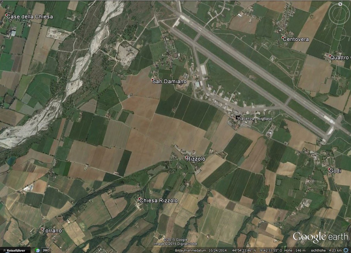
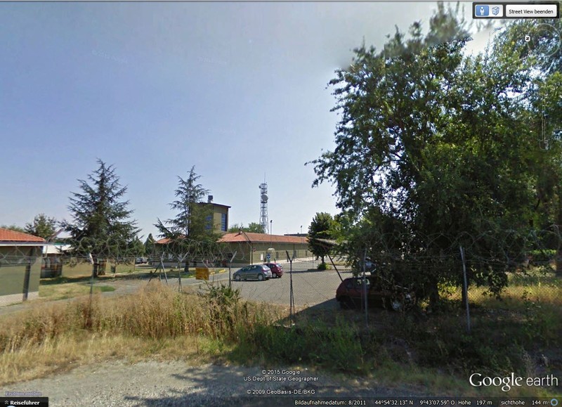
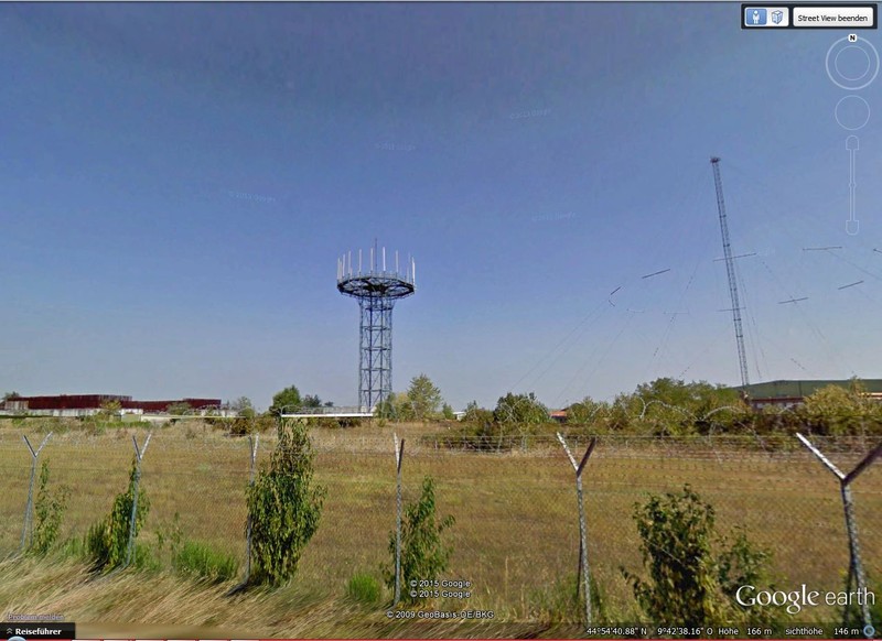
Basisseite "Locales nationales NATO System" - Station Piacenza - Air Base - National Site
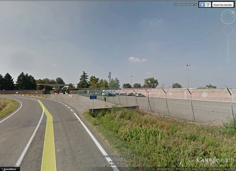
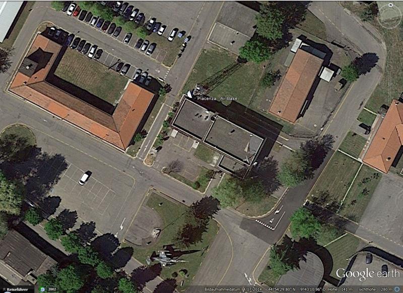
Piacenza - Station Piacenza - Air Base
Position : 44°54'30.47"N/9°43'10.82"O
Höhe üNN : 141 m
Status :
_________________________________________________________________________________________________________________________________________
Übersichtspläne - Bezeichnungen - Transmitterverbindungen


Locales nationales NATO System, Linienplan
Station Piacenza - Air Base > siehe Linienplan
_________________________________________________________________________________________________________________________________________

_________________________________________________________________________________________________________________________________________
Beschreibungen

________________________________________________________________________________________________________________________________________________________
Bild - Quellenangaben
(1) Google Earth/Google Street
_______________________________________________________________________________________________________________________________________________________
Text - Quellenangaben
[1]Wikipedia, Allied Joint Force Command Naples