Shetlands Tail - ACE-High-Journal
Hauptmenü:
- Homepage
-
AIRCENT 1952 > 1958
- Info Seite
- AIRCENT Linienplan
- Technik (Innen- Aussenbereich)
- Fontainebleau / Camp AIRCENT
- A-1. Fontainebleau / Terminal (AIRCENT)
- A-2. Croix d'Augas
- A-3. Melun
- A-4. Jossigny (s.Index)
- A-4. Marly-le-Roi / Terminal (SHAPE)
- A-5. Éméville
- A-6. Margival (Crouy)
- A-6 / D-1. Margival (Laffaux)
- A-7 / D-2. St. Erme
- A-8 / D-3. Poix-Terron (La Bascule)
- B-3. Angevillers (Molvange)
- Brassoir (s.Index)
- Brüssel-Evere / Terminal (NATO)
- C-1. Lüttelforst
- Mönchengladbach / Terminal (2. ATAF)
- C-2. Lammersdorf
-
LANDCENT 1952 >1962
- Info Seite
- LANDCENT Linienplan
- Technik (Innen- Aussenbereich)
- Bann (Kindsbach)
- Donnersberg
- Fontainebleau / Terminal B (LANDCENT)
- Mannheim / Terminal B (CENTAG)
- Mönchengladbach / Terminal B (NORTHAG)
- Münchweiler
- R 1. Dampleux
-
AFCENT/JCA 1962 >1967
- Info Seite
- AFCENT Linienplan
- Technik (Innen- Aussenbereich)
- 1. Fontainebleau, AFCENT HQ
- 2. Fontainebleau - Maintenance
- 3. St. Méry-Bombon
- 4. Bussières (La Haute-Maison)
- 4. La Haute-Maison
- 5. Dampleux
- 6. Lagery
- 7. St. Erme
- 8. Jossigny
- 9. Éméville
- 10. Margival (Laffaux)
- 11. Wahlhausen (ex St.24)
- Camp de Margival, AFCENT WHQ
- 12. Poix-Terron (La Bascule)
- 13. Vilosnes-Haraumont
- 14. Angevillers
- 15. Weiskirchen
- 16. Bann (Kindsbach)
- 17. Münchweiler
- 18. Marlemont
- 19. Vieux Moulins
- 20. Baraque-de-Fraiture
- 21. Maastricht
- Maastricht-Riemst (Bunker "Cannerberg")
- 21. Roclenge-sur-Geer
- 22. Lammersdorf
- 23. Rheindahlen
- Sonstige Stationen
- AFCENT CRICS 1967 >1979
-
AFCENT CIP 67, ab 1967
- Info Seite
- CIP 67 Linienplan
- Technik (Innen- Aussenbereich)
- Arnheim
- Aurich
- Bad Bergzabern (1) alte Liegenschaft
- Bad Bergzabern (2) neue Liegenschaft
- Baden-Söllingen
- Baraque-de-Fraiture
- Barnsdorf
- Battice (Fort)
- Beckum
- Bielefeld (Ebberg)
- Böblingen
- Bonn (Hardthöhe)
- Brockzetel
- Brunssum
- Damme
- Dietenwengen
- Dötlingen
- Drabenderhöhe
- Ellerspring
- Erbeskopf
- Börfink (Bunker-"Erwin")
- Euskirchen
- Feldberg
- Gross Reken
- Hehn
- Herkenbosch
- Himmelsberg
- Hochkelberg
- Hornisgrinde
- Ibbenbüren
- Irndorf
- Kesternich
- Kindsbach
- Kindsbach (Bunker-"Cave")
- Kolbenberg
- Lammersdorf
- Langerkopf
- Lantin
- Leistadt
- Leopoldsburg
- Lübbecke
- Maastricht
- Maastricht - Riemst (Bunker-"Cannerberg")
- Markelo
- Meßstetten
- Meßstetten (Bunker-"Martin")
- Mönchberg
- Münchweiler [Ruppertsweiler]
- Nordhelle
- Nottuln
- Oberabtsteinach
- Obertshausen
- Oldenburg
- Ottenstein
- Pirmasens-Husterhöhe
- Potzberg
- Prüm - Post (Air)
- ACE-High-System Europa
-
ACE-High-System, ACCHAN,ab 1958
- Info Seite
- England
-
ACE-High-System, AFNORTH,ab 1958
- Info Seite
-
Dänemark
- ACE-High System
- Sonstige Objekte
- Norwegen
-
ACE-High-System, AFCENT,ab 1958
- Info Seite
- Link Seiten-Übersicht
-
Deutschland
- ACE-High System
-
Exkursionen (D)
- Info Seite (D)
- Bonndorf - Wutachschlucht
- Freiburg - Bodensee Querweg
- Freudenstadt - Rothirschweg
- Freudenstadt - Holzmichelweg
- Hinterzarten - Ravennaschlucht
- Hinterzarten - rund um den Feldberg
- Kniebis - Lotharpfad
- Lübeck - Stralsund Ostseeradweg
- Pforzheim - Mittelweg
- Pforzheim - Ostweg
- Pforzheim - Westweg
- St Georgen - Pforzheim Wanderweg E8
- Stühlingen - Wehr Schluchtensteig I
- Stühlingen - Wehr Schluchtensteig II
- Triberg - Uhrenträgerweg
- Vossenack - Hürtgenwaldmarsch
- Exkursionen (SP)
- Gedenkstätten
-
Militärische Objekte
- Info Seite
- Air Base
- Bunker, nach WK II
- Munitionslager
- Nike FlaRak Stellungen
- NVA Stellungen
- Pershing FlaRak Stellungen
- Polygone Stellungen
- Transmitter
- Truppenübungsplatz-Kasernen
- U.S. Stellungen
-
WKII Objekte
- Info Seite
- Aurich - Flakstellung
- Bad Bergzabern - Museum
- Bad Münstereifel - FHQ "Felsennest"
- Gemünd - NS-Ordensburg Vogelsang
- Gemünd - Igel Stellung Vogelsang
- Kniebis - FHQ "Tannenberg"
- Lammersdorf - Höckerlinie
- Langschoß - Wasserbunker
- Niedersimten - Museum Gerstfeldhöhe
- Paustenbach - Eifelkreuz
- Schmithof - Höckerlinie
- Seebach (Hornisgrinde) - LVZ
- Simonskall - Museum Sanitätsbunker
-
Städte/Ortschaften
- Info Seite
- Baden-Württemberg
- Bayern
- Berlin
- Brandenburg
- Bremen
- Hamburg
- Hessen
- Mecklenburg-Vorpommern
- Niedersachsen
- Nordrhein-Westfalen
- Rheinland-Pfalz
- Saarland
- Sachsen
- Sachsen-Anhalt
- Schleswig-Holstein
- Thüringen
-
Sonstige Objekte
- Info Seite
- Calmbach - Klinik Charlottenhöhe
- Dannenfels - Ludwigsturm
- Feldberg - Horst Garbe
- Feldberg - Schwarzwald
- Feldberg - Taunus
- Karlsruhe - 2.tes Meeting
- Kniebis - Hotel Alexanderschanze
- Langschoß - Feuerwachtturm
- Mönchengladbach - Flughafen
- Mülheim - Flughafen
- Schwalmtal - Fabrikanlage
- Sinsheim - Technikmuseum
- Viersen-Süchteln Irmgardiskapelle
- Viersen-Süchteln Kriegerdenkmal
- Viersen-Süchten Wasserspeicher
- Weeze - Schloss Wissen
- Wollseifen - das Dorf
- Zivile Bunker
-
Zivile Transmitter
- Info Seite
- Alexanderschanze - Transmitter (Mobil)
- Baden-Baden, Merkurturm
- Bambergerhof - BNetzA Peiler
- Bremen Woltmershausen
- Bremen - Fernmeldeturm
- Dannenfels - Sender Donnersberg
- Düsseldorf - Rheinturm
- Gernsbach - Hohloh
- Gollenberg
- Großhau - Fernmeldeturm
- Lauschied
- Mönchengladbach - FMT
- Nettetal-Hinsbeck
- Nottuln - WDR Sender
- Ober-Abtsteinach - HR
- Reichweiler
- Schiefbahn - Fernmeldeturm
- Schömberg - Sender Langenbrand
- Seebach (Hornisgrinde) - Mobilfunk
- Seebach (Hornisgrinde) - SWR
- Seebach (Hornisgrinde) - Telekom
- Staffel - FMT
- Sulzbach-Rosenberg - Mobilfunk
- Sulzbach- Rosenberg
- Viersen-Bockert
- Viersen-Süchteln - Fernmeldeturm
- Waldböckelheim
- Wildeshausen
- Würselen- Mobilfunk
-
Belgien
- ACE-High System
- Gedenkstätten
-
Militärische Objekte
- Info Seite
-
Transmitter, BEMILCOM
- Info Seite
- Adinkerke, Site 030
- Ben-Ahin, Site Mx
- Battice, Site 024
- Brüssel-Evere / Terminal (NATO)
- Camp Elsenborn
- Court-Saint-Etienne, Site Mx
- D`Hoppe, Site Mx
- Everberg, Site 115
- Genk
- Hannut, Site 055
- Kester-Heide, Site 251
- Kester-Heide, Site Mx
- Langemark
- Latin, Site Mx
- Molenbeek (Site Mx)
- Millen, Site 056
- Millen, Site Mx
- Truppenübungsplatz-Kasernen
- WKI Festungen
- WKII Bunker
- WKII Festungen
- Städte/Ortschaften
- Sonstige Objekte
- Zivile Transmitter
-
Niederlande
- ACE-High System
- Gedenkstätten
- Militärische Objekte
- Städte/Ortschaften
- Sonstige Objekte
-
Frankreich
- ACE-High System
- Gedenkstätten
-
Militärische Objekte
- Info Seite
- Objekte-WKI
- Objekte-WKII
-
Objekte-Maginot-WKII
- Ligne Maginot Übersicht
- 8 S.F. de la Crusnes
-
9 S.F. de Thionville
- Ligne Maginot Übersicht
- 9 S.F. Thionville Übersicht
- Rochonvillers - Abri du Grand Lot
- Angevillers - Camp d`Angevillers
- Rochonvillers - Casemate d`Escherange Ouest
- Rochonvillers - Casemate du Grand Lot
- Rochonvillers - Blockhaus 1 - du Petit Lot
- Rochonvillers - Blockhaus 2 - du Petit Lot
- Rochonvillers - G.O. Rochonvillers Bloc 9
- Rochonvillers - G.O. Rochonvillers
- 10 S.F. de Boulay
- 12 S.F. de la Sarre
- 13 S.F. de Rohrbach
- 14 S.F. des Vosges
-
15 S.F. de Haguenau
- Ligne Maginot Übersicht
- 15 S.F. de Haguenau Übersicht
- Birlenbach - Abri de tir de Birlenbach
- Bremmelbach - Casemate Nord
- Drachenbronn - Casernement de Drachenbronn
- Drachenbronn - G.O. Hochwald Est
- Drachenbronn - G.O. Hochwald Ouest
- Hatten - Abri de Hatten
- Hatten - Abri de tir
- Hatten - Casemate Esch
- Hatten - Casemate la Selz
- Hatten - Observatoire
- Oberhof - G.O. Schoenenbourg
- Pfaffenschlick - Abri de tir Pfaffenschlick Sud
- Rittershoffen - Casemate du Bois 1
- Rittershoffen - Casemate du Bois 2
- Rittershoffen - Casemate du Bois 3
- Polygone Stellungen
- Städte/Ortschaften
- Sonstige Objekte
-
ACE-High-System, AFSOUTH,ab 1958
- Info Seite
- Link Seiten-Übersicht
-
Italien
- ACE-High System
- Exkursionen
-
Militärische Objekte
- Info Seite
- Festungswerke
- La grande Guerra
-
Städte/Ortschaften
- Info Seite
- Affi, Bastia San Michele
- Allumiere
- Agrigento
- Bagolino
- Breno
- Brescia
- Catania
- Collio
- Carrara
- Civitavècchia
- Firenze
- Genova
- Isola di Capri
- Isola di Ischia
- Isola di Procida
- Lago di Garda
- Lago di Idro
- Lago di Iseo
- Lago di Ledro
- Lerici
- Milano
- Monte Etna
- Monte Vesuvio
- Napoli
- Paestum
- Pompeji
- Pozzuoli
- Pisa
- Roma
- Savona
- Sicilia
- Siracusa
- Tuscania
- Tolfa
- Viareggio
- Venezia
- Viterbo
-
Locales NATO / NTTS System
- Info Seite
- Nationaler Linienplan
- Affi, "West Star", Site B
- Aviano, Air Base
- Brescia, Monte Maddalena, Site D
- Cansiglio, Site G
- Cavriana, Site ACE-High
- Collio, Dosso dei Galli, ACE-High
- Comano, Livorno, ACE-High
- Comiso, Air Base
- Concordia Sagittaria, ACE-High
- Erbezzo (Vaccamozzi), Rx Site, Site R
- Ghedi, Air Base
- Grezzana, "Back Yard", Site A
- La Gusella, Site F
- Lughezzano, SatCom F14
- Milano
- Monte Alto (VI), Site E
- Monte Comerlati (VR), Site W
- Motta di Livenza
- Negrar, Monte Tondo
- Padua, Monte Venda
- Piacenza, Air Base
- Pian Cavallo, Site J
- Poggio Renatico
- Sant`Anna D`alfaedo, Tx Site, Site T
- Site M (nicht aktiviert)
- Solbiate Olona
- Treviso - Istrana, Air Base
- Treviso - Sant Àngelo, Air Base
- Verona, Palazzo Carli
- Vicenza, Air Base, 5 ATAF
- Villafranca, Air Base
- Vittorio Veneto
- Volta Mantovana, Site C
-
Griechenland
- ACE-High System
- Städte/Ortschaften
- Türkei
-
NATO CRC, Kommandostand
- Info Seite
- Bunker Übersichtsplan
- England
- Norwegen
- Dänemark
-
Deutschland
- Bodenmais, Luftraumüberwachung (Großer Arber)
- Börfink, Bunker "Erwin"
- Brockzetel, Bunker "Balduin"
- Elmenhorst, Luftraumüberwachung
- Erndtebrück, Bunker "Erich"
- Lauda-Königshofen, Bunker "Gustav"
- Linnich, Bunker "Castlegate"
- Meßstetten, Bunker "Martin"
- Ruppertsweiler, Bunker "Arius-RUF"
- Schönewalde, CRC Bunker "Harald"
- Uedem, Bunker "Udo"
-
Belgien
- Bassenge-Glons, Site CRC
- Mons-Casteau, Bunker "SHAPE Command Center"
- Niederlande
- Frankreich
- Griechenland
- Spanien
-
Italien
- Nationaler Linienplan
-
Affi, Bunker "Weststar"
- Affi, Bunker "Weststar"
- Affi, Bunker "Weststar" Bilddokumentationen 2008-2011
- Affi, Bunker "Weststar" Bilddokumentationen 2016-2019
- Affi, "Weststar" Publikationen
- Affi, Bunker "Monte Moscal"
- Affi, Bunker "San Michele"
- Affi, Heliport Albare
- Erbezzo (Vaccamozi), Rx Site, Site R
- Sant`Anna D`alfaedo, Tx Site, Site T
- Grezzana, Bunker "Back Yard"
- Mondragone, Bunker "Proto"
- Martina Franca, Bunker "3° ROC"
- Padua, Bunker "Monte Venda" 1° ROC
- Rocca di Papa, Bunker "Monte Cavo" 2° ROC
- Sant `Oreste, Bunker "Monte Soratte"
- Türkei
- NATO CAOC, Kommandostand
- NADGE System
- Schweiz, Festungswerke
- NATO SatCom, ab 1968
- RAF UK
-
RAF UK > BAOR, Scatterlink
- Info Seite
- Deutschland
- England
-
BAOR Germany
- Info Seite
- BAOR Übersichtsplan
- Arsbeck, BAD Sub-Depot
- Arsbeck, Rifle Range
- Arsbeck, Training Area
- Birgelen, BFBS Transmitter
- Birgelen, Fernmeldeanlage
- Birgelen, Mercury Barracks
- Brüggen-Bracht, Munitionsdepot
- Brüggen-Elmpt, Air Base Ammunition Compound
- Brüggen-Elmpt, Air Base, Javelin Barracks (Elmpt Station)
- Brüggen-Elmpt, Transmitter
- Hostert, British Miliary Hospital ( Kent School)
- Krefeld, Richtfunk
- Krefeld, Rifle Range
- Krefeld, Bradbury Barracks
- Krefeld, Haynes Barracks
- Lammersdorf, Roetgen
- Mönchengladbach, Rotunda Barracks
- Mönchengladbach, Rotunda Barracks Annex
-
ET-A, Scope Comm, ab 1966
- Info Seite
- ET-A Linienplan
- Belgien
- Deutschland
- England
- Frankreich
- Niederlande
-
486L Medcom, ab 1960
- Info Seite
- 486L Linienplan
- England
- Griechenland
- Italien
- Spanien
- Türkei
- News - Gästebuch Impressum
NATO ACE-High-System - 1962 bis 1995
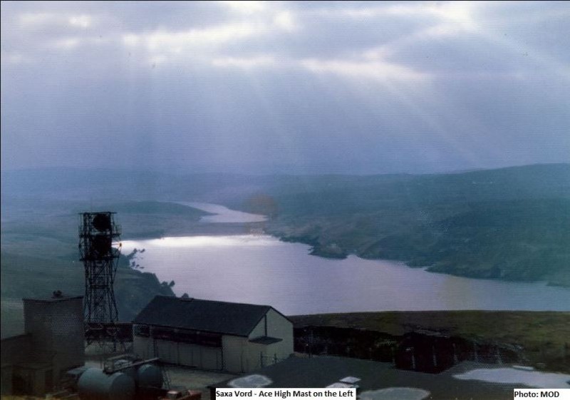
Basisseite "ACE-High System" - Shetlands Tail (Saxa Vord)
Norwick - Station Shetlands Tail (Saxa Vord)
Position : 60°49'36.95"N/0°50'22.47"W - 276 m.üNN
Site Code : (eac) USVZ
Status : Aufgegebene Nutzung
____________________________________________________________________________________________________________________________________________
Übersichtspläne - Bezeichnungen - Transmitterverbindungen
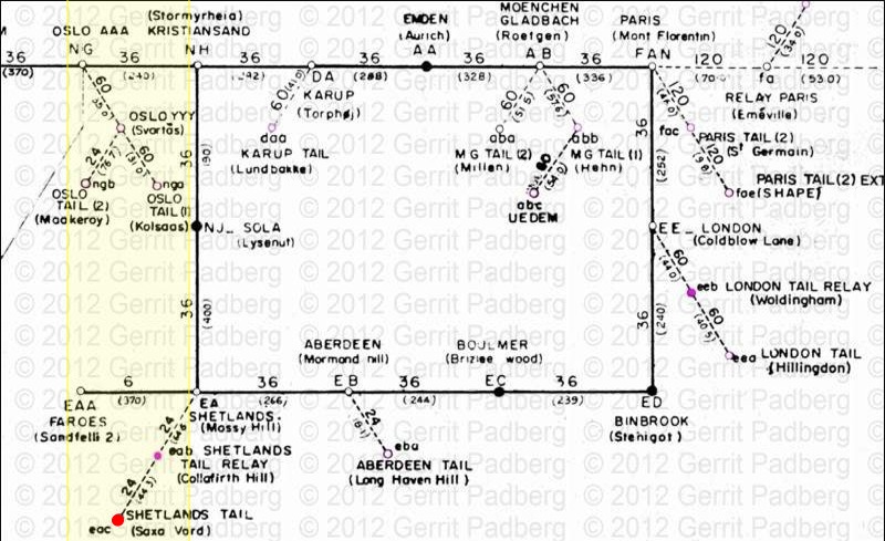

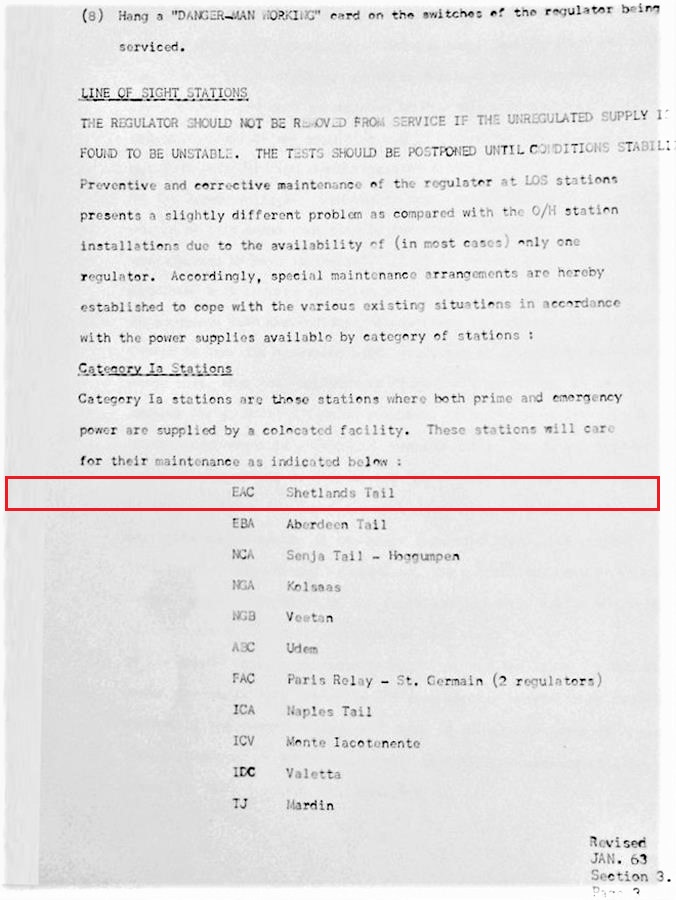
Station eac, Power Category - I a
Station Transmitter Typ - 1R (Radio Line)
_____________________________________________________________________________________________________________________________________
NATO Linienplan - von 1959
eac - Shetlands Tail (Saxa Vord) > eab - Shetlands Tail Relay (Collafirth Hill) - L.o.S.-Line - Station mit Multiplex
Channel Capacity 24 - Entfernung zwischen den Stationen - Luftlinie - 44,50 Km
_______________________________________________________________________________________________________________________________________________________
NATO Linienplan - von 1976 - Revision 1981
USVZ - Shetlands Tail (Saxa Vord) > UCOZ - Shetlands Tail Relay (Collafirth Hill) - L.o.S.-Line - Station mit Multiplex
Channel Capacity 24 - Entfernung zwischen den Stationen - Luftlinie - 44,50 Km
_______________________________________________________________________________________________________________________________________________________
SatCom Übersichtsplan - von 1976 - Revision 1981
USVZ - Shetlands Tail (Saxa Vord) > SatCom Station F29 - Saxa Vord
Entfernung zwischen den Stationen - Luftlinie - 0,19 Km
____________________________________________________________________________________________________________________________________________
Link Seiten, Wikipedia

Thema - List of former Royal Air Force stations [1]
Autor - Wikipedia
Quelle - Wikipedia
ULR - Wikipedia
_______________________________________________________________________________________________________________________________________________________
Link Seiten, sonstige Publikationen
Thema : A History of RAF Saxa Vord
Autor : Gordon Carle [2]
Quelle : ACE High in Shetland [2]
ULR : http://ahistoryofrafsaxavord.blogspot.de/2011/04/ace-high-in-shetland.html
"ACE-High in Shetland
ACE-High was a NATO communications system which stretched over 8,000 miles from north Norway to eastern Turkey. Its purpose was to provide early warning links and to permit commanders to discuss strategy during the cold war period. Its’ origins were in the mid 50’s and it has now been superseded by other communications links. Over 80 ground stations were involved, half of which used large aerial arrays to propagate high frequency radio signals which were “bounced” over the horizon using tropospheric forward scatter techniques (hence FSS Mossy Hill – Forward Scatter Station). These Units also had microwave aerials which linked into the other sites, using line of sight techniques. The smaller stations were off-shoots from the main line of larger stations. I will leave the experts to explain the system in more detail. There is a good article on the Ace-High System on the Subbrit site here:
http://www.subbrit.org.uk/rsg/features/ace_high/index.html
So, back to the subject of this section, Ace High in Shetland. There were four main elements to the system in Shetland, Mossy Hill in the south mainland with its large tropospheric scatter arrays and microwave tower, 2 microwave “off-shoot” sites at Collafirth Hill and Saxa Vord and; fourthly, an admin and accommodation site at Maybury Camp at Virkie in the south mainland." [1]
____________________________________________________________________________________________________________________________________________
Beschreibungen
"ACE-High Station Shetlands Tail (Saxa Vord)" - die Daten
- Die ACE-High Station Shetlands Tail wurde in den Jahren "o.A" bis "o.A" erbaut und ging nach einer Testphase in die offizielle Betriebsphase.
- Die Bezeichnung der ACE-High Station lautete nach der offizielen Inbetriebnahme der Station "Shetlands Tail (Saxa Vord)" und die NATO Code hierzu war "eac".
- eac - Shetlands Tail (Saxa Vord) (e) England (ac) NATO Codierung - Station ac
- 1971 wurden die ACE-High Stationen im "ACE-High Network Europe" neu codiert, die Bezeichnung der ACE-High Station lautete danach "Shetlands Tail (Saxa Vord)" und die NATO Code hierzu war "USVZ"
- USVZ- Shetlands Tail (Saxa Vord) (U) United Kingdom of Great Britain (SV) Shetlands Tail (Saxa Vord) / Stadt- Geländebezeichnung (Z) ACE-High System
- 1991, Die Betriebsphase endete im Januar mit Schliessung der ACE-High Station.
"ACE-High-Station Shetlands Tail (Saxa Vord)" - die Geschichte (1)
- "RAF Saxa Vord is a remote radarstation providing long-range radar coverage of its approaches. The data is fed into the Integrated Command and Control System within the UK"

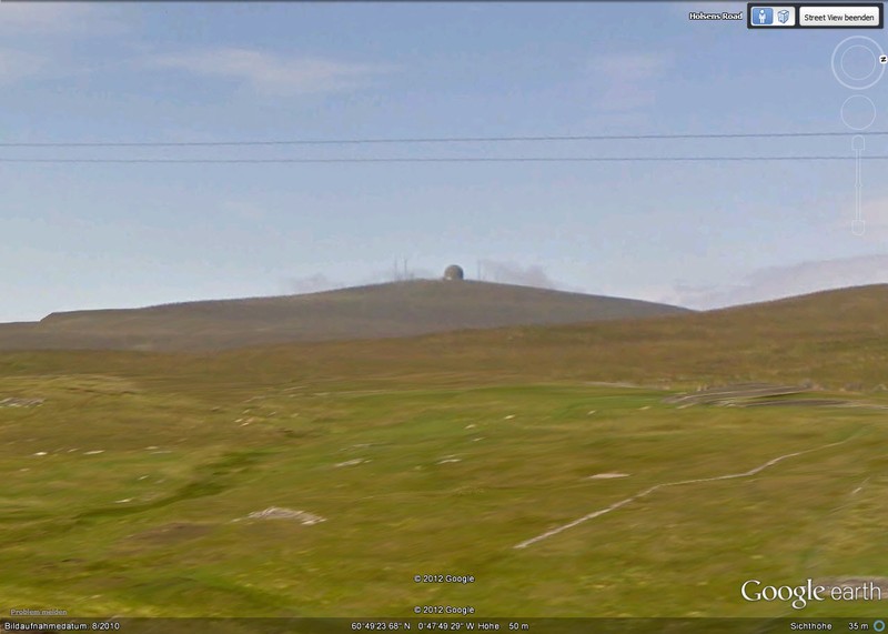
"ACE-High-Station Shetlands Tail (Saxa Vord)" - heute (1)
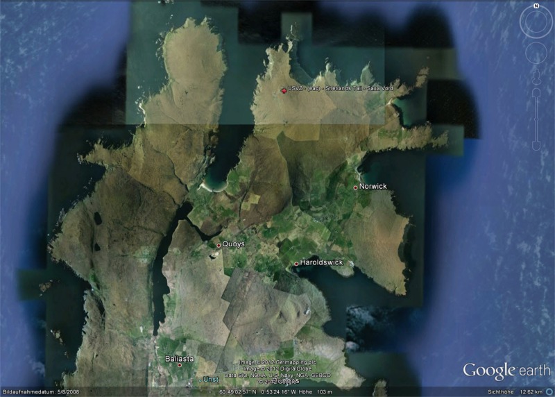
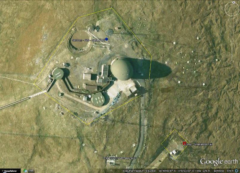
2008, Das Gelände der Liegenschaft, mit den vorhandenen Gebäuden, ist unter Google Earth erkennbar
_______________________________________________________________________________________________________________________________________________________
Bild - Quellenangaben
(1) Google Earth/Google Street
(2) Quellenschutz, ID 201_01
(3) Wikipedia, Allied Forces Northwestern Europe
_______________________________________________________________________________________________________________________________________________________
Text - Quellenangaben
[1] Wikipedia, List of former Royal Air Force stations
[2] A History of RAF Saxa Vord, Gordon Carle
[2] http://ahistoryofrafsaxavord.blogspot.de/2011/04/ace-high-in-shetland.html
[3] NATO Handbuch, Volume I, Oktober 1959