Bremerhaven - ACE-High-Journal
Hauptmenü:
- Homepage
-
AIRCENT 1952 > 1958
- Info Seite
- AIRCENT Linienplan
- Technik (Innen- Aussenbereich)
- Fontainebleau / Camp AIRCENT
- A-1. Fontainebleau / Terminal (AIRCENT)
- A-2. Croix d'Augas
- A-3. Melun
- A-4. Jossigny (s.Index)
- A-4. Marly-le-Roi / Terminal (SHAPE)
- A-5. Éméville
- A-6. Margival (Crouy)
- A-6 / D-1. Margival (Laffaux)
- A-7 / D-2. St. Erme
- A-8 / D-3. Poix-Terron (La Bascule)
- B-3. Angevillers (Molvange)
- Brassoir (s.Index)
- Brüssel-Evere / Terminal (NATO)
- C-1. Lüttelforst
- Mönchengladbach / Terminal (2. ATAF)
- C-2. Lammersdorf
-
LANDCENT 1952 >1962
- Info Seite
- LANDCENT Linienplan
- Technik (Innen- Aussenbereich)
- Bann (Kindsbach)
- Donnersberg
- Fontainebleau / Terminal B (LANDCENT)
- Mannheim / Terminal B (CENTAG)
- Mönchengladbach / Terminal B (NORTHAG)
- Münchweiler
- R 1. Dampleux
-
AFCENT/JCA 1962 >1967
- Info Seite
- AFCENT Linienplan
- Technik (Innen- Aussenbereich)
- 1. Fontainebleau, AFCENT HQ
- 2. Fontainebleau - Maintenance
- 3. St. Méry-Bombon
- 4. Bussières (La Haute-Maison)
- 4. La Haute-Maison
- 5. Dampleux
- 6. Lagery
- 7. St. Erme
- 8. Jossigny
- 9. Éméville
- 10. Margival (Laffaux)
- 11. Wahlhausen (ex St.24)
- Camp de Margival, AFCENT WHQ
- 12. Poix-Terron (La Bascule)
- 13. Vilosnes-Haraumont
- 14. Angevillers
- 15. Weiskirchen
- 16. Bann (Kindsbach)
- 17. Münchweiler
- 18. Marlemont
- 19. Vieux Moulins
- 20. Baraque-de-Fraiture
- 21. Maastricht
- Maastricht-Riemst (Bunker "Cannerberg")
- 21. Roclenge-sur-Geer
- 22. Lammersdorf
- 23. Rheindahlen
- Sonstige Stationen
- AFCENT CRICS 1967 >1979
-
AFCENT CIP 67, ab 1967
- Info Seite
- CIP 67 Linienplan
- Technik (Innen- Aussenbereich)
- Arnheim
- Aurich
- Bad Bergzabern (1) alte Liegenschaft
- Bad Bergzabern (2) neue Liegenschaft
- Baden-Söllingen
- Baraque-de-Fraiture
- Barnsdorf
- Battice (Fort)
- Beckum
- Bielefeld (Ebberg)
- Böblingen
- Bonn (Hardthöhe)
- Brockzetel
- Brunssum
- Damme
- Dietenwengen
- Dötlingen
- Drabenderhöhe
- Ellerspring
- Erbeskopf
- Börfink (Bunker-"Erwin")
- Euskirchen
- Feldberg
- Gross Reken
- Hehn
- Herkenbosch
- Himmelsberg
- Hochkelberg
- Hornisgrinde
- Ibbenbüren
- Irndorf
- Kesternich
- Kindsbach
- Kindsbach (Bunker-"Cave")
- Kolbenberg
- Lammersdorf
- Langerkopf
- Lantin
- Leistadt
- Leopoldsburg
- Lübbecke
- Maastricht
- Maastricht - Riemst (Bunker-"Cannerberg")
- Markelo
- Meßstetten
- Meßstetten (Bunker-"Martin")
- Mönchberg
- Münchweiler [Ruppertsweiler]
- Nordhelle
- Nottuln
- Oberabtsteinach
- Obertshausen
- Oldenburg
- Ottenstein
- Pirmasens-Husterhöhe
- Potzberg
- Prüm - Post (Air)
- ACE-High-System Europa
-
ACE-High-System, ACCHAN,ab 1958
- Info Seite
- England
-
ACE-High-System, AFNORTH,ab 1958
- Info Seite
-
Dänemark
- ACE-High System
- Sonstige Objekte
- Norwegen
-
ACE-High-System, AFCENT,ab 1958
- Info Seite
- Link Seiten-Übersicht
-
Deutschland
- ACE-High System
-
Exkursionen (D)
- Info Seite (D)
- Bonndorf - Wutachschlucht
- Freiburg - Bodensee Querweg
- Freudenstadt - Rothirschweg
- Freudenstadt - Holzmichelweg
- Hinterzarten - Ravennaschlucht
- Hinterzarten - rund um den Feldberg
- Kniebis - Lotharpfad
- Lübeck - Stralsund Ostseeradweg
- Pforzheim - Mittelweg
- Pforzheim - Ostweg
- Pforzheim - Westweg
- St Georgen - Pforzheim Wanderweg E8
- Stühlingen - Wehr Schluchtensteig I
- Stühlingen - Wehr Schluchtensteig II
- Triberg - Uhrenträgerweg
- Vossenack - Hürtgenwaldmarsch
- Exkursionen (SP)
- Gedenkstätten
-
Militärische Objekte
- Info Seite
- Air Base
- Bunker, nach WK II
- Munitionslager
- Nike FlaRak Stellungen
- NVA Stellungen
- Pershing FlaRak Stellungen
- Polygone Stellungen
- Transmitter
- Truppenübungsplatz-Kasernen
- U.S. Stellungen
-
WKII Objekte
- Info Seite
- Aurich - Flakstellung
- Bad Bergzabern - Museum
- Bad Münstereifel - FHQ "Felsennest"
- Gemünd - NS-Ordensburg Vogelsang
- Gemünd - Igel Stellung Vogelsang
- Kniebis - FHQ "Tannenberg"
- Lammersdorf - Höckerlinie
- Langschoß - Wasserbunker
- Niedersimten - Museum Gerstfeldhöhe
- Paustenbach - Eifelkreuz
- Schmithof - Höckerlinie
- Seebach (Hornisgrinde) - LVZ
- Simonskall - Museum Sanitätsbunker
-
Städte/Ortschaften
- Info Seite
- Baden-Württemberg
- Bayern
- Berlin
- Brandenburg
- Bremen
- Hamburg
- Hessen
- Mecklenburg-Vorpommern
- Niedersachsen
- Nordrhein-Westfalen
- Rheinland-Pfalz
- Saarland
- Sachsen
- Sachsen-Anhalt
- Schleswig-Holstein
- Thüringen
-
Sonstige Objekte
- Info Seite
- Calmbach - Klinik Charlottenhöhe
- Dannenfels - Ludwigsturm
- Feldberg - Horst Garbe
- Feldberg - Schwarzwald
- Feldberg - Taunus
- Karlsruhe - 2.tes Meeting
- Kniebis - Hotel Alexanderschanze
- Langschoß - Feuerwachtturm
- Mönchengladbach - Flughafen
- Mülheim - Flughafen
- Schwalmtal - Fabrikanlage
- Sinsheim - Technikmuseum
- Viersen-Süchteln Irmgardiskapelle
- Viersen-Süchteln Kriegerdenkmal
- Viersen-Süchten Wasserspeicher
- Weeze - Schloss Wissen
- Wollseifen - das Dorf
- Zivile Bunker
-
Zivile Transmitter
- Info Seite
- Alexanderschanze - Transmitter (Mobil)
- Baden-Baden, Merkurturm
- Bambergerhof - BNetzA Peiler
- Bremen Woltmershausen
- Bremen - Fernmeldeturm
- Dannenfels - Sender Donnersberg
- Düsseldorf - Rheinturm
- Gernsbach - Hohloh
- Gollenberg
- Großhau - Fernmeldeturm
- Lauschied
- Mönchengladbach - FMT
- Nettetal-Hinsbeck
- Nottuln - WDR Sender
- Ober-Abtsteinach - HR
- Reichweiler
- Schiefbahn - Fernmeldeturm
- Schömberg - Sender Langenbrand
- Seebach (Hornisgrinde) - Mobilfunk
- Seebach (Hornisgrinde) - SWR
- Seebach (Hornisgrinde) - Telekom
- Staffel - FMT
- Sulzbach-Rosenberg - Mobilfunk
- Sulzbach- Rosenberg
- Viersen-Bockert
- Viersen-Süchteln - Fernmeldeturm
- Waldböckelheim
- Wildeshausen
- Würselen- Mobilfunk
-
Belgien
- ACE-High System
- Gedenkstätten
-
Militärische Objekte
- Info Seite
-
Transmitter, BEMILCOM
- Info Seite
- Adinkerke, Site 030
- Ben-Ahin, Site Mx
- Battice, Site 024
- Brüssel-Evere / Terminal (NATO)
- Camp Elsenborn
- Court-Saint-Etienne, Site Mx
- D`Hoppe, Site Mx
- Everberg, Site 115
- Genk
- Hannut, Site 055
- Kester-Heide, Site 251
- Kester-Heide, Site Mx
- Langemark
- Latin, Site Mx
- Molenbeek (Site Mx)
- Millen, Site 056
- Millen, Site Mx
- Truppenübungsplatz-Kasernen
- WKI Festungen
- WKII Bunker
- WKII Festungen
- Städte/Ortschaften
- Sonstige Objekte
- Zivile Transmitter
-
Niederlande
- ACE-High System
- Gedenkstätten
- Militärische Objekte
- Städte/Ortschaften
- Sonstige Objekte
-
Frankreich
- ACE-High System
- Gedenkstätten
-
Militärische Objekte
- Info Seite
- Objekte-WKI
- Objekte-WKII
-
Objekte-Maginot-WKII
- Ligne Maginot Übersicht
- 8 S.F. de la Crusnes
-
9 S.F. de Thionville
- Ligne Maginot Übersicht
- 9 S.F. Thionville Übersicht
- Rochonvillers - Abri du Grand Lot
- Angevillers - Camp d`Angevillers
- Rochonvillers - Casemate d`Escherange Ouest
- Rochonvillers - Casemate du Grand Lot
- Rochonvillers - Blockhaus 1 - du Petit Lot
- Rochonvillers - Blockhaus 2 - du Petit Lot
- Rochonvillers - G.O. Rochonvillers Bloc 9
- Rochonvillers - G.O. Rochonvillers
- 10 S.F. de Boulay
- 12 S.F. de la Sarre
- 13 S.F. de Rohrbach
- 14 S.F. des Vosges
-
15 S.F. de Haguenau
- Ligne Maginot Übersicht
- 15 S.F. de Haguenau Übersicht
- Birlenbach - Abri de tir de Birlenbach
- Bremmelbach - Casemate Nord
- Drachenbronn - Casernement de Drachenbronn
- Drachenbronn - G.O. Hochwald Est
- Drachenbronn - G.O. Hochwald Ouest
- Hatten - Abri de Hatten
- Hatten - Abri de tir
- Hatten - Casemate Esch
- Hatten - Casemate la Selz
- Hatten - Observatoire
- Oberhof - G.O. Schoenenbourg
- Pfaffenschlick - Abri de tir Pfaffenschlick Sud
- Rittershoffen - Casemate du Bois 1
- Rittershoffen - Casemate du Bois 2
- Rittershoffen - Casemate du Bois 3
- Polygone Stellungen
- Städte/Ortschaften
- Sonstige Objekte
-
ACE-High-System, AFSOUTH,ab 1958
- Info Seite
- Link Seiten-Übersicht
-
Italien
- ACE-High System
- Exkursionen
-
Militärische Objekte
- Info Seite
- Festungswerke
- La grande Guerra
-
Städte/Ortschaften
- Info Seite
- Affi, Bastia San Michele
- Allumiere
- Agrigento
- Bagolino
- Breno
- Brescia
- Catania
- Collio
- Carrara
- Civitavècchia
- Firenze
- Genova
- Isola di Capri
- Isola di Ischia
- Isola di Procida
- Lago di Garda
- Lago di Idro
- Lago di Iseo
- Lago di Ledro
- Lerici
- Milano
- Monte Etna
- Monte Vesuvio
- Napoli
- Paestum
- Pompeji
- Pozzuoli
- Pisa
- Roma
- Savona
- Sicilia
- Siracusa
- Tuscania
- Tolfa
- Viareggio
- Venezia
- Viterbo
-
Locales NATO / NTTS System
- Info Seite
- Nationaler Linienplan
- Affi, "West Star", Site B
- Aviano, Air Base
- Brescia, Monte Maddalena, Site D
- Cansiglio, Site G
- Cavriana, Site ACE-High
- Collio, Dosso dei Galli, ACE-High
- Comano, Livorno, ACE-High
- Comiso, Air Base
- Concordia Sagittaria, ACE-High
- Erbezzo (Vaccamozzi), Rx Site, Site R
- Ghedi, Air Base
- Grezzana, "Back Yard", Site A
- La Gusella, Site F
- Lughezzano, SatCom F14
- Milano
- Monte Alto (VI), Site E
- Monte Comerlati (VR), Site W
- Motta di Livenza
- Negrar, Monte Tondo
- Padua, Monte Venda
- Piacenza, Air Base
- Pian Cavallo, Site J
- Poggio Renatico
- Sant`Anna D`alfaedo, Tx Site, Site T
- Site M (nicht aktiviert)
- Solbiate Olona
- Treviso - Istrana, Air Base
- Treviso - Sant Àngelo, Air Base
- Verona, Palazzo Carli
- Vicenza, Air Base, 5 ATAF
- Villafranca, Air Base
- Vittorio Veneto
- Volta Mantovana, Site C
-
Griechenland
- ACE-High System
- Städte/Ortschaften
- Türkei
-
NATO CRC, Kommandostand
- Info Seite
- Bunker Übersichtsplan
- England
- Norwegen
- Dänemark
-
Deutschland
- Bodenmais, Luftraumüberwachung (Großer Arber)
- Börfink, Bunker "Erwin"
- Brockzetel, Bunker "Balduin"
- Elmenhorst, Luftraumüberwachung
- Erndtebrück, Bunker "Erich"
- Lauda-Königshofen, Bunker "Gustav"
- Linnich, Bunker "Castlegate"
- Meßstetten, Bunker "Martin"
- Ruppertsweiler, Bunker "Arius-RUF"
- Schönewalde, CRC Bunker "Harald"
- Uedem, Bunker "Udo"
-
Belgien
- Bassenge-Glons, Site CRC
- Mons-Casteau, Bunker "SHAPE Command Center"
- Niederlande
- Frankreich
- Griechenland
- Spanien
-
Italien
- Nationaler Linienplan
-
Affi, Bunker "Weststar"
- Affi, Bunker "Weststar"
- Affi, Bunker "Weststar" Bilddokumentationen 2008-2011
- Affi, Bunker "Weststar" Bilddokumentationen 2016-2019
- Affi, "Weststar" Publikationen
- Affi, Bunker "Monte Moscal"
- Affi, Bunker "San Michele"
- Affi, Heliport Albare
- Erbezzo (Vaccamozi), Rx Site, Site R
- Sant`Anna D`alfaedo, Tx Site, Site T
- Grezzana, Bunker "Back Yard"
- Mondragone, Bunker "Proto"
- Martina Franca, Bunker "3° ROC"
- Padua, Bunker "Monte Venda" 1° ROC
- Rocca di Papa, Bunker "Monte Cavo" 2° ROC
- Sant `Oreste, Bunker "Monte Soratte"
- Türkei
- NATO CAOC, Kommandostand
- NADGE System
- Schweiz, Festungswerke
- NATO SatCom, ab 1968
- RAF UK
-
RAF UK > BAOR, Scatterlink
- Info Seite
- Deutschland
- England
-
BAOR Germany
- Info Seite
- BAOR Übersichtsplan
- Arsbeck, BAD Sub-Depot
- Arsbeck, Rifle Range
- Arsbeck, Training Area
- Birgelen, BFBS Transmitter
- Birgelen, Fernmeldeanlage
- Birgelen, Mercury Barracks
- Brüggen-Bracht, Munitionsdepot
- Brüggen-Elmpt, Air Base Ammunition Compound
- Brüggen-Elmpt, Air Base, Javelin Barracks (Elmpt Station)
- Brüggen-Elmpt, Transmitter
- Hostert, British Miliary Hospital ( Kent School)
- Krefeld, Richtfunk
- Krefeld, Rifle Range
- Krefeld, Bradbury Barracks
- Krefeld, Haynes Barracks
- Lammersdorf, Roetgen
- Mönchengladbach, Rotunda Barracks
- Mönchengladbach, Rotunda Barracks Annex
-
ET-A, Scope Comm, ab 1966
- Info Seite
- ET-A Linienplan
- Belgien
- Deutschland
- England
- Frankreich
- Niederlande
-
486L Medcom, ab 1960
- Info Seite
- 486L Linienplan
- England
- Griechenland
- Italien
- Spanien
- Türkei
- News - Gästebuch Impressum
ET-A, Scope Comm, ab 1966 > Deutschland
Basisseite "ET-A System" - Station Bremerhaven (Carl-Schurz Kaserne)
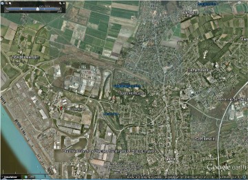
Bremerhaven - Station Bremerhaven (Carl-Schurz Kaserne)
Position : 53°35'10.34"N/8°33'05.37"O --2 m.üNN
Site Code : 52
Site : o.A
Status : unbekannt
Status heute : unbekannt
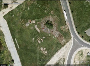
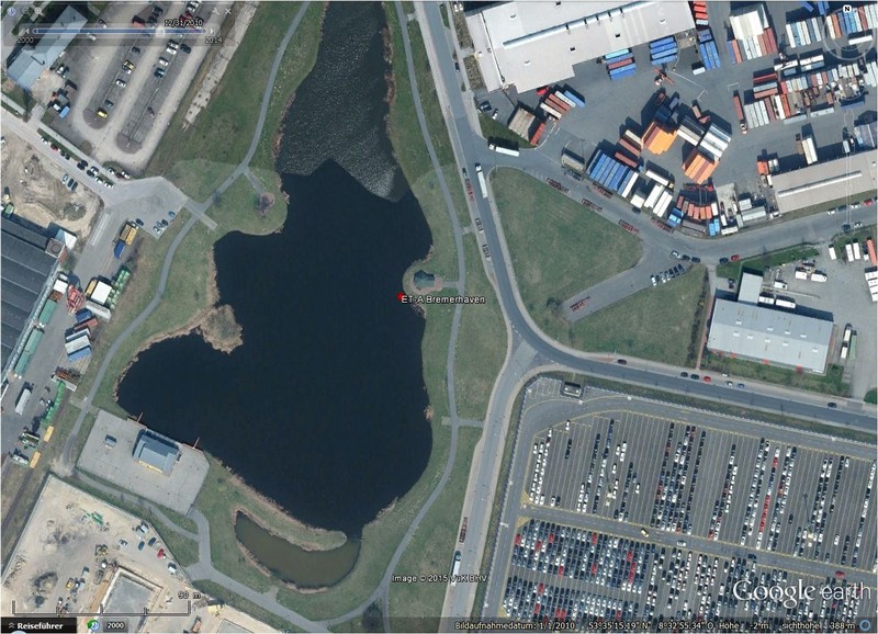
Ansicht : (1)
_______________________________________________________________________________________________________________________________________________________
Übersichtspläne - Bezeichnungen - Transmitterverbindungen


ET-A System - Linienplan, von 1966
Bremerhaven
________________________________________________________________________________________________________________________________________________________________________________
Entfernung zwischen den Stationen - Luftlinie - 175,00 Km
_______________________________________________________________________________________________________________________________________________________
Link Seiten, Wikipedia

Thema - Liste der geschlossenen amerikanischen Militärstandorte in Deutschland [2]
Autor - Wikipedia
Quelle - Wikipedia
URL - Wikipedia
_______________________________________________________________________________________________________________________________________________________
Beschreibungen
"ET-A Station Bremerhaven" - die Daten
"ET-A Station Bremerhaven" - die Geschichte
"Although northwest Germany was to become a British occupation zone, an exclave was granted to the US Army in the area between Bremen and Nordholz. The US needed a support point with a harbour, to allow the unhindered support of US forces in the American Occupation Zone in Southern Germany. The US Army moved into the airfield as early as May 1945, and used the port to return troops from Europe to the United States. Until 1947 the US airforce also used the Nordholz Airbase.
Initially several locations were used by the Americans, but over time they were reduced in number until by the 1960s they all merged into the joint location referred to as the "Staging Area" and became home to units of the US Army Terminal Command, Europe (USATCEUR), US Navy, US Coast Guard and US Air Force. In 1973 the barracks were renamed Carl Schurz Barracks.After the Cold War ended the US reduced their presence in Germany. In an effort to further reduce costs most of the goods were sent through the Dutch port of Rotterdam, ending the need for Bremerhaven. This ended the American presence and the military units were withdrawn in 1993, leaving only a small civilian contignent to coordinate the remaining transshipments.Today, the former airfield has been redeveloped into a large storage yard for the Bremerhaven shipping facilities."[1]
"ET-A Station Bremerhaven" - heute (1)
Das Gelände der Liegenschaft, mit den vorhandenen Gebäuden, ist unter Google Earth erkennbar.
________________________________________________________________________________________________________________________________________________________
Bild - Quellenangaben
(1) Google Earth/Google Street
________________________________________________________________________________________________________________________________________________________
Text - Quellenangaben
[1] Wikipedia, Bremerhaven Army Airfield
[1] https://en.wikipedia.org/wiki/Bremerhaven_Army_Airfield
[2] Wikipedia, Liste der geschlossenen amerikanischen Militärstandorte in Deutschland
[2] https://de.wikipedia.org/wiki/Liste_der_geschlossenen_amerikanischen_Militärstandorte_in_Deutschland
Homepage | AIRCENT 1952 > 1958 | LANDCENT 1952 >1962 | AFCENT/JCA 1962 >1967 | AFCENT CRICS 1967 >1979 | AFCENT CIP 67, ab 1967 | ACE-High-System Europa | ACE-High-System, ACCHAN,ab 1958 | ACE-High-System, AFNORTH,ab 1958 | ACE-High-System, AFCENT,ab 1958 | ACE-High-System, AFSOUTH,ab 1958 | NATO CRC, Kommandostand | NATO CAOC, Kommandostand | NADGE System | Schweiz, Festungswerke | NATO SatCom, ab 1968 | RAF UK | RAF UK > BAOR, Scatterlink | BAOR Germany | ET-A, Scope Comm, ab 1966 | 486L Medcom, ab 1960 | News - Gästebuch Impressum | Generelle Seitenstruktur