Hostert - Kent School - ACE-High-Journal
Hauptmenü:
- Homepage
- Das ACE-High-System 1962 > 1995
-
ACE-High-System Bereiche
-
ACCHAN
- Info Seite
-
England
- London
- London Tail Relay
- London Tail
- Binbrook
- Boulmer
- Aberdeen Tail
- Aberdeen
- Shetlands
- Shetlands Tail Relay
- Shetlands Tail
- Faroes
-
Umgebung - Militärische Objekte
- Royal Air Force - UK
- AFNORTH
-
AFCENT
- Info Seite
-
Deutschland
- Aurich
- Uedem
- Hehn
- Kindsbach
- Lammersdorf
- Lammersdorf Bilddokumentationen
- MG Tail (2) Millen
- MG Tail (2) Maastricht
- Feldberg
-
Umgebung - Militärische Objekte
-
BAOR Germany
- Arsbeck - BAD Sub - Depot
- Arsbeck - Rifle Range
- Arsbeck - Training Area
- Birgelen - Mercury Barracks
- Bracht - Munitionsdepot
- Brüggen - Air Base - Javelin Barracks (Elmpt Station)
- Hehn - BFBS Transmitter
- Hehn - Logistic/Support
- Hostert - Kent School
- Lammersdorf - Station Roetgen
- Mönchengladbach - Ayrshire Barracks North
- Mönchengladbach - Ayrshire Barracks South
- Mönchengladbach - Rotunda Barracks
- Mönchengladbach - Rotunda Barracks Annex
- Mönchengladbach - JHQ
- Rheindahlen - JHQ - Cemetery
- Rheindahlen - JHQ -Schießanlage
- Rheindahlen - JHQ - Airfield
- Rheindahlen - JHQ - Siedlung
- St.Tönis - Francisca Barracks
- Wegberg - Hospital
- Wildenrath - Air Base
- Willich - Kitchener Barracks
- Nike Site
- Objekte WKII
- Pershing Site
- Westwall WKII
- US Site
- Sonstige Objekte
-
BAOR Germany
- Umgebung - Zivile Objekte
-
Belgien
- Chievres
- Casteau (HQ SHAPE)
- Adinkerke
- Baraque-de-Fraiture
-
Umgebung - Militärische Objekte
- Lüttich - Festungen WKI
- Lüttich - Festungen WKII
- Sonstige Objekte
- Umgebung - Zivile Objekte
-
Niederlande
- Maastricht
- Brunssum
- Umgebung - Militärische Objekte
- Umgebung - Zivile Objekte
-
Frankreich
- Emeville
- Nice
- Paris North
- Paris South
- Rohrbach
- Paris Tail (2) St.Germain
- Paris Tail (2) (Extension - SHAPE)
- Paris Tail (1) (Laffaux)
- Rozoy Bellevalle
- Taverny
- Lyon
-
Umgebung - Militärische Objekte
- Festungen - WKI
- Objekte WKII
-
Maginot Linie - WKII
- 8 S.F. de la Crusnes
- Longuyon - Fort Fermont
- 9 S.F. de Thionville
- Rochonvillers - Abri du Grand Lot
- Angevillers - Camp d`Angevillers
- Rochonvillers - Casemate d`Escherange Ouest
- Rochonvillers - Casemate du Grand Lot
- Rochonvillers - Blockhaus 1 - du Petit Lot
- Rochonvillers - Blockhaus 2 - du Petit Lot
- Rochonvillers - Ouvrage Rochonvillers
- 12 S.F. de la Sarre
- Achern - Ouvrage Haute-Poirier
- Rohrbach > Achern
- 13 S.F. de Rohrbach
- Bitche - Ouvrage Simserhof
- Bitche - Casemate Lègeret
- Rohrbach - Casemate de Bining
- Rohrbach - Ouvrage Rohrbach
- Singling - Ouvrage Welschhof
- 14 S.F. des Vosges
- Lembach - Ouvrage Four-à-Chaux
- 15 S.F. de Haguenau
- Hatten - Abri de Hatten
- Hatten - Abri de tir
- Hatten - Casemate Esch
- Hatten - Casemate la Selz
- Hatten - Observatoire
- Oberhof - Ouvrage de Schoenenbourg
- Rittershoffen - Casemate du Bois 1
- Rittershoffen - Casemate du Bois 2
- Rittershoffen - Casemate du Bois 3
- Sonstige Objekte
- Umgebung - Zivile Objekte
-
AFSOUTH
- Info Seite
-
Italien
- Dosso dei Galli
- Dosso dei Galli Bilddokumentationen
- Martina Franca
- Verona Tail
- Verona Torre 4
- Latina School
- Rome Tail
- Livorno
- Livorno Bilddokumentationen
- Rome
- Naples Tail
- Naples
- Lame Concordia
- Aviano
- Monte Vergine
- Monte Vulture
- Monte Iacotenente
- Pietra Ficcata
- Cavriana
- Catanzaro
- Monte Lauro
- Malta
- Locales NATO / NTTS System
-
Umgebung-Zivile Objekte
- Affi - Bastia San Michele
- Allumiere
- Agrigento
- Bagolino
- Brescia
- Breno
- Carrara
- Catania
- Civitavècchia
- Collio
- Firenze
- Genova
- Isola di Capri
- Isola di Ischia
- Isola di Procida
- Lago di Garda
- Lago di Idro
- Lago di Iseo
- Lago di Ledro
- Lago di Vacca
- Lerici
- Milano
- Monte Etna
- Monte Vesuvio
- Napoli
- Paestum
- Pompeji
- Pozzuoli
- Pisa
- Roma
- Savona
- Sicilia
- Siracusa
- Tuscania
- Tolfa
- Viareggio
- Venezia
- Viterbo
- Umgebung-Militärische Objekte
-
Griechenland
- Keffalinia
- Athens
- Ziros
- Athens Tail
- Larissa
- Larissa Tail
- Vitsi
- Ismaros
- Umgebung - Zivile Objekte
- Türkei
-
ACCHAN
-
Verbunkerte Anlagen, oder Kommandostäbe
- England
- Norwegen
- Dänemark
-
Deutschland
- "Balduin" Brockzetel
- "Balduin" Luftraumüberwachung
- "Balduin" Rx Site
- "Balduin" Tx Site
- "Castlegate" Linnich
- "Cave" Kindsbach
- "Erwin" Börfink
- "Erwin" Luftraumüberwachung
- "Erwin" Rx Site
- "Erwin" Tx Site
- "Erich" Erndtebrück
- "Erich" Luftraumüberwachung
- "Erich" Rx Site
- "Erich" Tx Site
- "Kirspenich THW3"
- "Marienthal THW2"
- "Martin" Messstetten
- "Martin" Luftraumüberwachung
- "Martin" Rx Site
- "Martin" Tx Site
- "GSVBw 44" St. Martin
- Staffel - Postbunker
- Nörvenich - Fliegerhorst
- "Udo" Uedem
- "Udo" Luftraumübewachung
- "Udo" Rx Site
- "Udo" Tx Site
- "Steinfurt" Satzvey
- Belgien
- Niederlande
- Frankreich
- Spanien
- Italien
- Griechenland
- Türkei
-
NATO SatCom 1968 > heute
- Info Seite
- F1 Kester
- F2 Euskirchen
- F3 Northwest
- F4 Oakhanger
- F5 Eggemoen
- F6 Ankara
- F7 Civitaveccia
- F8 Carp
- F9 Schoonhoven
- F10 Lundebakke
- F11 Atalanti
-
AFCENT Microwave 1952 > heute
-
AIRCENT 1952 > 1958
- Info Seite
- A-1.Camp de Glieres
- A-2.Hauteurs de la Solle
- A-3.Melun
- A-4.Marly le Roi
- 4.Jossigny
- 5.Emeville
- 6.Margival
- 7.St.Erme
- 8.Poix - Terron
- Vilosnes-Haraumont
- Molvange-Angevillers
- Perl-Eft
- Terminal (Trier-Euren)
- Weiskirchen
- Bann
- Münchweiler
- Terminal (Seckenheim)
- Liart
- Vieux Moulins
- Baraque-de-Fraiture
- Roclenge-s-Geer
- Lammersdorf
- Lüttelforst
- Terminal (Mönchengladbach)
-
LANDCENT 1952 >1962
- Info Seite
- Terminal B - La Madeleine
- Croix d`Augas
- La Haute Maison
- Dampleux
- Terminal A - Soissons
- Camp de Margival
- Marlemont
- "ohne Angabe"
- Grandmenil
- Baraque Michel
- Terminal B - Mönchengladbach
- Stonne
- Vilosnes - Haraumont
- Camp d`Angevillers
- Weiskirchen
- Bann/Kindsbach
- Münchweiler
- Freisen
- Donnersberg
- Terminal B Mannheim-Seckenheim
-
AFCENT 1962 >1967
- Info Seite
- 1 Camp Guynemer
- 2 Fontainebleau - Maintenance
- 3 St. Mery Bombon
- 4 Bussieres (La Haute Maison)
- 5 Dampleux
- 6 Lagery
- 7 St.Erme
- 8 Jossigny
- 9 Emeville
- 10 Margival-Laffaux
- 11 Wahlhausen
- 12 La Bascule
- 13 Vilosnes-Haraumont
- 14 Angevillers
- Camp d`Angevillers
- 15 Weiskirchen
- 16 Bann/Kindsbach
- 17 Münchweiler
- 18 Marlemont
- 19 Les Hauts Buttes/Vieux Moulins
- 20 Baraque-de-Fraiture
- 21 Roclenge-sur-Geer
- Maastricht
- Bunker Cannerberg
- 22 Lammersdorf
- 23 Mönchengladbach/Rheindahlen
- Prüm-Air Station
- AFCENT CRICS 1967 >1979
-
AFCENT CIP 67 1967 > heute
- Info Seite
- Arnheim
- Aurich
- Bad Bergzabern
- Baraque-de-Fraiture
- Bann
- Barnsdorf
- Beckum
- Brockzetel
- Böblingen
- Bonn
- Brunssum
- Bielefeld
- Damme
- Drabenderhöhe
- Dietenwengen
- Baden-Söllingen
- Himmelsberg
- Irndorf
- Schammach
- Dötlingen
- Euskirchen
- Ellerspring
- Erbeskopf
- Feldberg
- Battice
- Gross Reken
- Hehn
- Herkenbosch
- Hornisgrinde
- Hochkelberg
- Kindsbach Cave
- Kolbenberg
- Kesternich
- Lammersdorf
- Lantin (Mx)
- Langerkopf
- Lübbecke
- Leistadt
- Leopoldsburg
- Maastricht
- Markelo
- Messstetten
- Mönchberg
- Nottuln
- Nordhelle
- Oldenburg
- Obertshausen
- Oberabtsteinach
- Ottenstein
- Senden
- Püm - Post (Air)
- Pirmasens Husterhöhe
- Potzberg
- Stein - Neukirch
- Soest - Büecke
- Spa - Malchamps
- Stocksberg
- Ibbenbüren
- Uedem
- Ulm
- Varel
- Vessem
- Vught
- Wiesensteig
- Zutendaal
-
Sonstige Stationen
- Adinkerke-Site 30
- Bad Münstereifel
- Baumholder
- Battice-Site 24
- Genk
- Rettersen
- Ruppertsweiler
- Hottorf
- Brüssel SHAPE
- Kester-Heide-Site 251
- Kester-Heide (Mx)
- Hannunt-Site 55
- Hannunt - RTB
- Everberg
- Kleinhau
- Langemark
- Teveren
- Camp Elsenborn
- Maikammer - Kalmit
- Millen-Site 56
- Millen (Mx)
- Ben Ahin
- Schöneberg
- Court-Saint-Etienne
-
AIRCENT 1952 > 1958
- News - Gästebuch - Impressum
- Arsbeck - BAD Sub - Depot
- Arsbeck - Rifle Range
- Arsbeck - Training Area
- Birgelen - Mercury Barracks
- Bracht - Munitionsdepot
- Brüggen - Air Base - Javelin Barracks (Elmpt Station)
- Hehn - BFBS Transmitter
- Hehn - Logistic/Support
- Hostert - Kent School
- Lammersdorf - Station Roetgen
- Mönchengladbach - Ayrshire Barracks North
- Mönchengladbach - Ayrshire Barracks South
- Mönchengladbach - Rotunda Barracks
- Mönchengladbach - Rotunda Barracks Annex
- Mönchengladbach - JHQ
- Rheindahlen - JHQ - Cemetery
- Rheindahlen - JHQ -Schießanlage
- Rheindahlen - JHQ - Airfield
- Rheindahlen - JHQ - Siedlung
- St.Tönis - Francisca Barracks
- Wegberg - Hospital
- Wildenrath - Air Base
- Willich - Kitchener Barracks
ACE-High-System Bereiche > AFCENT > Deutschland > Umgebung - Militärische Objekte > BAOR Germany
Umgebung - ACE-High Station - Deutschland - Militärische Objekte - BAOR Germany
Hostert - British Miliary Hospital, bis 1963
Hostert - Kent School, ab 1962 - 1991
Hostert - Kent School
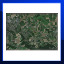
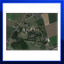
Position : 51°12'34.83"N/6°18'15.72"EHöhe üNN : 68 m
Ansicht : Hostert, Kent School, 2015
Umgebung: Luftlinie - 7,16 Km > ACE-High Station Hehn
________________________________________________________________________________________________________________________________________________________
Übersichtspläne - Bezeichnungen - Transmitterverbindungen
________________________________________________________________________________________________________________________________________________________
Link Seiten
Thema - BAOR Locations, Hostert - British Military Hospital > Kent School [2]
Autor - BAOR Locations
Quelle - BAOR Locations
________________________________________________________________________________________________________________________________________________________
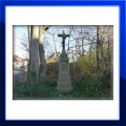
Bilddokumentationen, 2015
________________________________________________________________________________________________________________________________________________________
Beschreibungen
British Military Hospital Hostert
ab den 50er Jahren,
1963 geschlossen.
Kent School Hostert ab den 60er Jahren,
1991 geschlossen
________________________________________________________________________________________________________________________________________________________
Bild - Quellenangaben
(1) Google Earth/Google Street
Text - Quellenangaben
[1] Wikipedia, British Army of the Rhine
[2] BAOR Locations, British Military Hospital / Kent School


